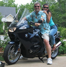
Last night's thunderstorms gave quite a lightning show in Nashville, but as hoped for they cleared the air and cooled the countryside for our drive home today. The sky was partly cloudy and with the rain-cooled air, the weather was perfect for a ride. The Tennessee hillsides were covered with lush vegetation and it was clear that they had been receiving ample rainfall this season. As we got further east, we went through steadily hilly terrain, and the limestone that underlays most of this region was exposed in every roadcut. And, of course, it wasn't too long before we happened on the first of the ubiquitous road signs encouraging us to "See Rock City."
Nickajack Lake, a reservoir on the Tennessee River downstream of Chattanooga, was nearly empty, and no doubt the few waterskiers we could see were enjoying a Monday of flat water to themselves. Of course, the calm and beauty of that scene quickly gave way to the frantic crush of traffic that starts at Chattanooga and only gets worse all the way to Atlanta. Ugh...some things never change. The traffic in Lawrenceville (GA) still sucks...in fact, the traffic sucked all the way from Chattanooga to Lawrenceville.
But, as is always the case when you return from a long trip, every familiar little thing you see along the road -- e.g. road signs and water towers -- reminds you of home, and the remaining miles can't pass too quickly.
We rolled into the driveway about 3:30 in the afternoon, and as glad as Gi and I were to back, I don't think anyone was happier than Tyler. No doubt, in a day or two I'll be daydreaming about being back on the road, but for now I'm going to luxuriate in the comfortable surroundings of home.
I haven't worked up all the statistics for the trip, but we were on the road 29 days and traveled a bit over 7500 miles (12,000 kilometers). We passed through 19 US states and 3 Canadian provinces.
Also, for easy future reference, here's the revised map for the route home from Saskatoon.
View Larger Map
Monday, July 13, 2009
Sunday, July 12, 2009
Flatter than Kansas!
Morning broke gray and humid, and when we flipped on the TV the Weather Channel was showing a huge thunderstorm complex bearing down on Kansas City, 100 miles to our rear. The route to Nashville runs through one of the worst parts of Tornado Alley so we flew out the door, hoping to outrun the storm. The first couple of hours were pretty unmemorable, but then we got to St. Louis, at the confluence of the Missouri and Mississippi Rivers. Gi got a couple of nice shots of the Gateway Arch, the iconic symbol of the city designed by Eero Saarinen.
Crossing the Mississippi River, into southern Illinois I realized that the farmland between the Mississippi and Ohio Rivers was actually much flatter than the Kansas landscape Gi had commented on earlier in the trip. I guess you don't hear people comment on this very much because dense woods typically border the roads in this area and you only see the flat bottomlands through occasional gaps or when the road goes up and over a bridge or overpass. The lushness of the woods is not surprising given the heat, humidity and abundant water. What did surprise me, though, was the abundance and diversity of wildflowers. Rudbeckias, Queen Anne's lace, morning glory, butterfly weed (Asclepius), trumpet vine, false aster and pink phlox were all in bloom, and most were there naturally. The purple coneflowers and penstemmon blooming along the roadsides in the Dakotas were beautiful, but the flowers here were amazing. (Sorry that there were no photos to do them justice, but shooting objects only 20 feet away while traveling 80 mph yields nothing but blurs.)
The floral diversity in this area also extended to the woods lining the road with oaks, hickories, elms, maples, sycamores, tupelos, catalapas crowding the roadside. The seed pods on these catalapas were already quite long, and reminded me of a catalapa Gi and I saw in the park in Kamloops. (I was surprised to know they could survive that far norht.) In places, pines and redcedar had pioneered the bare soils left in road cuts, but they are rapidly being crowded to an early death by shade from the broadleaf trees.
This area is also a hotspot for tornadoes and damaging winds. In numerous places along the roadside the trees were mangled and snapped. There were freshly downed trees as well as trees that had been blown over months or years before. A lot of the tall tree that were still standing had a funny morphology that obviously resulted from the small upper limbs being ripped from the tree tops, after which short twigs and dense foliage sprouted directly from primary branches and trunks. The results were trees that look like something from a Dr. Seuss book.
We finally crossed the Ohio River into Paducah, KY and, as usual, barge traffic was thick on the river. We got doused by rain in Paducah, and for only the second time ever stopped to take shelter for a few minutes under an interstate overpass. After stowing the camera we made another start, but had to pull over again to take shelter in a Waffle House. One burger and couple of cups of coffee later we were on our way to Nashville, and our timing couldn't have worked out better. We arrived at the hotel about 15 minutes behind a huge thunderstorm, then, about two hours after we checked in, the storm from Kansas City blew in behind us with lots of lightning and some vicious wind. Hopefully, these storms will cool things off ahead of us, and make the final 6 hour ride home tomorrow pleasant and uneventful.
Saturday, July 11, 2009
Down the Missouri Valley
Gi's anxious to get home as quickly as possible, and when we got up this morning the weather in the central plains was relatively quiet, so we decided to head straight down the Missouri Valley through Sioux Falls, Sioux City, Council Bluffs, hang a left at Kansas City, and spend the night in Columbia, MO. It's a long ride -- about eight and a half hours -- but it sets us up to be home on Monday afternoon. (Sorry Bruce, a stop by Indy will have to wait until I come up to Lafayette in October.) There was a large thunderstorm complex in central Nebraska when we hit the road, but we were able to slip past catching just a few sprinkles on the leading edge of the rain.
The scenery was standard Midwest farm country -- big red barns amid seas of corn -- but this was my first trip north to south through this area and it helped me better appreciate how the rich soils had developed. The area between Brookings and Sioux Falls marks the boundary of the terminal moraines from the last glaciation, and in the cornfields near where we started we saw scattered piles of the rounded boulders that farmers had plowed up in their fields, but further south as we dropped into the Sioux River Basin we could see 50-60 ft cross-sections of the loess soils exposed by erosion from the river. These soils, comprised mainly of rock flour and dust from the glaciers, makes for incredibly rich soils which run hundreds of feet deep in some places.
Further south the bluffs along the river rise higher, but are covered with desne forest so that the geology only peeks through here and there. The temperature and humidity was pleasant through Iowa due to the cloud cover, but the skies cleared when we hit Missouri, and gusty winds from the northeast bounced Gi around quite a bit. Around St. Joseph someone turned on the humidity machine, and we knew we were finally back in the South. There has been a lot of rain through this area in recent weeks, which was easy to see from the rivers, as well as from the general mugginess.
The last couple of shots are for certain members of this audience. Crossing the Missouri River at Kansas City Gi caught a quick shot of the Showboat Casino, which I seem to recall was a place where Jan and Bob took me for an evening of gambling quite a few years ago. the other picture is of a car show that Gi spotted being held In a Bass Pro Shops parking lot just east of KC. Can anyone spot the Mopar entries?
From KC to Columbia we ran in and out of the edges of rain showers, but we were lucky and didn't hit any heavy rains. We later learned that those showers turned into heavy thunderstorms south of the interstate, so indeed it was a matter of lucky timing for us.
Dinner tonight was pretty good. A contemporary Italian place in Columbia called Sophie's. We'll see if we can beat it tomorrow night in Nashville.
Friday, July 10, 2009
You knew it had to happen sometime
It started as a gorgeous day for a ride -- bright skies, dry air and temps around 60F. The landscape stayed pretty much the same as we headed southeast from Minot on Hwy 52. The two-lane road followed the river valley and rail line, and accasionally wound around the abundant shallow lakes filled with cattails and reeds. The cattails were, in fact, so abundant I wondered whether North Dakota shouldn't have then as the state flower and perhaps the red-winged blackbird as the state bird. It's very pretty country, but you can't go far without reminders that the population is in decline, whether it's an old gray abandoned house with windows agape, or a lovely clapboard church up for sale.
Around midday, coming through Jamestown, ND, we looked south through town to see storm clouds brewing. Later this evening we learned that the same storm had touched off a tornado earlier in the day a few hundred miles to the west of us. We got caught by a coal train at an intersection downtown, and Gi couldn't resist snapping another picture as the engine roared by. (She's been snapping pictures of trains all along the route so far. I'm not sure why she has such fascination, but she really like seeing this one up so close.) My big regret is that as we pulled out of town and I spotted an Oscar Mayer Wienermobile parked outside a motel I didn't turn around and go back to snap a picture of the bike with the Weinermobile.
(Added July 17 -- Now I'm doubly disappointed for not turning around for that Weinermobile photo. It looks as if the driver crashed it into a house in Wisconsin just a few days later.)
It's almost hard to believe, but I managed to travel around 6,000 miles of this trip before the long arm of the law finally reached out and tapped me on the shoulder. A very nice South Dakota Highway Patrolman pulled me over to remind me that it's illegal to drive 10 mph over the speed limit. (10 MPH! I'm shocked!!!) So now I've got another warning to tack up on my wall of shame.
We stopped at a place called The Ram in downtown Brookings for dinner. The prime rib was excellent and the prices were very reasonable.
Thursday, July 9, 2009
Why not Minot?!
Morning in Saskatoon was gray and a broad band of rain showers was heading directly toward the city, so we pulled up stakes and headed south. The weather forecasts for Regina and Winnipeg were not very encouraging, and with the weather moving to the northeast, south looked to be our best choice. My original plan had been to head to Minot, ND rather than Winnipeg because North Dakota was one of only two states I have never visited (Alaska is the other), but Winnipeg is a big enough city that I could have the bike worked on there if necessary. Since the bike has been fine and the tires are good, Minot was back on the itinerary.
The countryside here is wide open so you can see rain showers coming from some distance off. You don't always have a choice of roads to take to avoid them, but we arrived at Moose Jaw just after noon as a large thunderstorm passed through and headed for Regina, our next destination. We stopped for lunch and to let the storm pass, and then opted to head due south from Moose Jaw on SA36. We then took SA13 to Weyburn, which proved a roundabout way that added at least an hour to our trip, but at least kept us dry. We stopped to stretch at this intersection and I snapped the two pictures below -- one looking back north the way we came at storm clouds, and the second looking east in the direction we turned. One picture that I'm sorry we missed was of a group of trophy-size bull elk that were grazing in fenced pastureland out in the middle of nowhere. I presume it was a game ranch, but didn't see any signs calling attention to the place.
From Weyburn it was another 90 minutes or so through Estevan (the "Energy City" of Saskatchewan -- so named for the oil, gas and coal in the area) to the US border. I'm not sure why my mind's eye always pictures North Dakota as brown and beige -- maybe it's all those images of combines harvesting ripe wheat in the fall -- but certainly at this time of the year the landscape is nothing but green so that even foxtail grass waving in the wind looks beautiful. And despite that unrelenting wind, the skies (and ponds) is full of birds -- Red-winged blackbirds, bobolinks, meadow larks, woodcock, gulls, falcons, doves, even a lone pelican. It's obvious that the pothole lakes that dot the countryside still provide quality habitat for enormous populations of birds. There are also a lot of predators. Gi saw her first wild coyote along the roadside, and I saw several badgers as well as their favorite food -- prairie dogs.
The extra ride time made for a very long day and the wind didn't help. There are few trees in this region, and the road only occasionally drops into valleys below the horizon, so there's little shelter from the wind. When the road ran east so it was to our back everything was fine, but a lot of legs today ran due south, and we were hammered by 25 mph gusty winds. Not much fun for the driver and even less so for the passenger. Gi deserves a merit badge for ridership today. That wind is enough to drive a person mad, so perhaps it's no wonder that the population in this area is in decline and farmsteads are being abandoned at an increasing rate. (Or at least they were before last year's economic shocks.)
We spent the night in a Fairfield Inn and I noticed one of the Google Streetview recording cars parked in the hotel lot. I guess they really have recorded just about every last street in America if they're now doing Minot, ND!
At this point we're ad libbing the route home. We've put the kabosh on any further layover days as I think we are both ready to be home. We have several equally attractive (or unattractive) routes home, so we'll probably play it by ear for the next couple of days. All I know at the moment is that our next stop will be Brookings, SD.
Wednesday, July 8, 2009
Starting the long ride home
The weather report was bad Tuesday morning for our 3-4 hour drive from Jasper to Edmonton. The entire has been suffering a real drought for the past couple of years, and wouldn't you know that the first real break in many weeks has to coincide with our drive. But, that's part of the game when you tour by bike, so we just battened down our luggage and shimmied into extra layers of so-called water-proof clothing.
Actually, the weather within the park was nicer that morning that it had been the previous day on our drive to Maligne Lake. The sun even tried to peak out onto Mt. Edith Cavell, which we hadn't seen since our drive into Jasper. However, no sooner did we hit the east boundary of the park, but the rain started. Needless to say the camera got packed away at this point.
The rain was cold and steady,but not the sort of deluge that would force us to stop, except for warmth and food. We did pull into a truck stop near Robb, about halfway to Edmonton, where the sympathetic owner and her help doted on us with multiple cups of hot coffee and soup. Just about the time my gear had stopped dripping on the floor we decided to gear back up and head on to our final destination.
I'm sure that we looked pretty bedraggled by the time we reached the home of our hostess, my friend and colleague Janice Cooke, her husband, Barry, her nine-month old son, Brandon, and their cat, Marmalade. Barry was delayed at an out of town meeting, but Janice, Gi, Brandon and I had a lovely, salad-rich dinner and a lot of delightful conversation after dinner. However, that cold rain had really sapped us, so Gi and I turned in fairly early.
Janice and I had a meeting on campus this morning to chat with one of her colleagues about a conifer genomics project, and as these things often do, our meeting ran long. The weather was pretty unsettled when we left the house that morning, and by the time we got back to the house around 1 PM we were under a tornado watch. At that point we decided that we should probably just stay another night with the Cooke's, but when I checked the weather again around 2:30 I could see a small window of opportunity to get out of Edmonton and reach Saskatoon with minimal rain. We just had to run the breach through one narrow line of thunderstorms.
We hit that line of thunderstorms about an hour out of Edmonton, and I guess we were about as lucky as you can get making that sort of run. We were in cold, hard rain for about 30 minutes (the storms had grown wider a bit while we were in transit), but all the heavy lightning stayed to the south of the road, and we didn't really hit any heavy buffeting winds. Right after we broke through the other side of the storm line I pulled over for gas and snapped a couple photos of the storm clouds and a distant shot of a canola field that was still getting rain.
The rest of the ride into Saskatoon was like riding through a painting of some pastoral fantasy. There were huge blue skies over endless plains of green wheat or bright yellow canola. Here and there on the horizon were grain elevators and in between were small neat farms with tidy barns and silos. We got into town just ahead of sundown (forgot we were losing an hour at the border), which was a good thing since the chill was just starting to get noticeable, even through our heavy gear.
Tomorrow it's a bit of a wait and see game. I don't intend to stay in Saskatoon, it's a tough little town that these days seems to thrive mainly on resource extraction, and so reminds me of the roughness I grew up with in Rock Springs. The weather is still iffy for the morning, but should improve as the day goes on. Don't if we'll make Winnipeg, but we'll be somewhere between here and there tomorrow night.
Subscribe to:
Posts (Atom)